J. Rowe Heritage Consulting
Visit me at
  • Home
    • Books for Sale
    • Favourite Links
    • Contact Me
  • Services
    • Previous Clients
    • Previous Projects
  • Wawa Heritage Doors
    • William Teddy
    • Louise Towab
    • Bernard Alphonse (Al) Turcott
    • Agnes Turcott
    • Sir James Dunn
    • Lady Dunn
    • Glenn Gould
    • Operation Michipicoten
    • Angus Bethune
    • Joe Ball
    • Aime Breton
    • Tom Surluga
    • Francis Hector Clergue
    • Atillio Berdusco
    • Rod Morrison Sr.
    • Mickey Clement
    • Keith Messenger
    • Alex Ross
  • Photo Gallery
  • 1910 Log of the North Shore Club
  • Northern Chronicles et al
  • Blog - Unearthed Treasures
  • Finding A.Y. Jackson in Wawa

Hudson's Bay Company 350th - A Michipicoten Milestone

5/10/2020

2 Comments

 
Picture
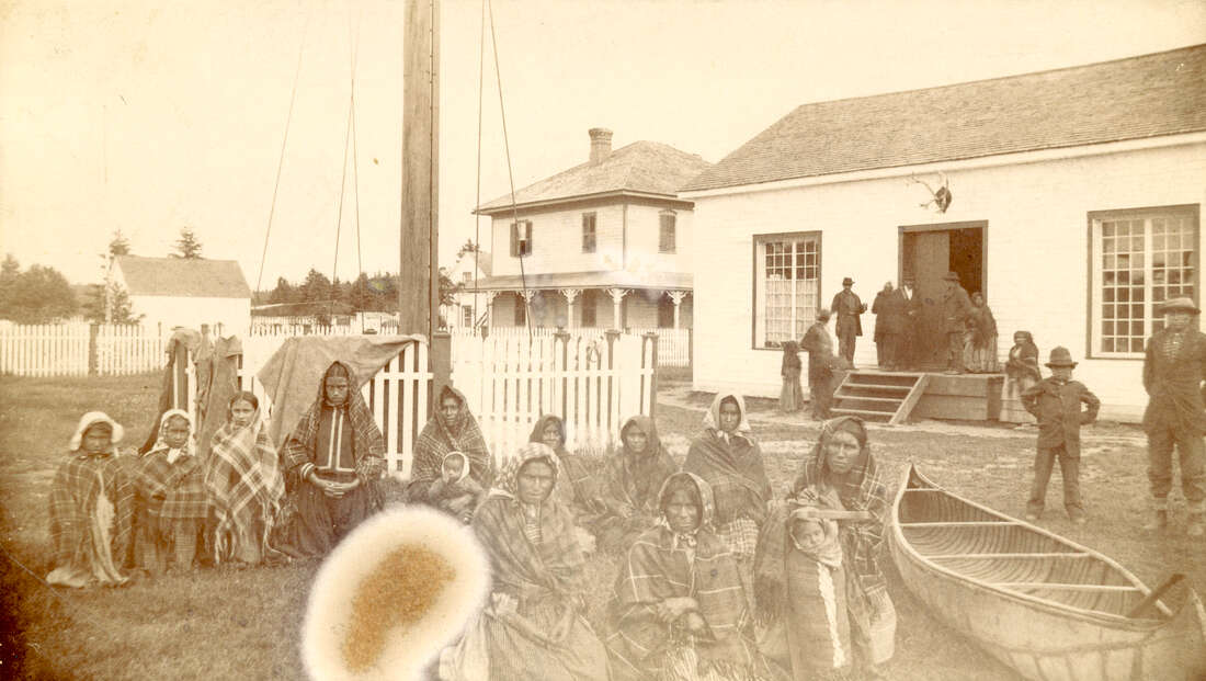
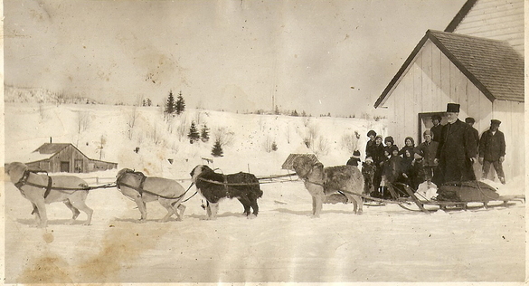
Photo caption:  Women and children at HBCo post - Courtesy of City of Vancouver Archives, c. 1883
On May 9, 2020, the Hudson’s Bay Company will reach a milestone.  It is currently the oldest, continuously operating trading company in the world and as of this coming Saturday, the HBCo will have accumulated 350 years under its wool blanketed belt.  No other company has had such an impact on the very fabric of our continent and country.  The HBCo has also played a significant role in the rich story of the Wawa area.  Our town may be small, but you would be surprised how much of the HBCo story is woven into the fabric of Michipicoten’s rich tapestry.
​
Think back to your grade school history class when we learned about a couple of adventurous French traders and explorers affectionately called “Radishes and Gooseberries”.  Pierre-Esprit Radisson and his brother-in-law Medard des Groseilliers lost faith in France’s royal court and potential financiers, which resulted in them leaving their countrymen and offering their services and first-hand knowledge of North America’s bountiful fur reserves to King Charles II of England.  On May 9, 1670, a royal charter was granted to the Governor and Company of Adventurers trading into Hudson’s Bay and the Hudson’s Bay Company was formed.  All waters flowing into the Hudson’s Bay were included in this grant which included the Moose and Missinabi River basins which Radisson learned could be accessed through Michipicoten and Lake Superior.  Life in North America would never be the same again.

The birth and evolution of the fur trade could not have been achieved without the guidance, trust and knowledge of the Indigeneous Peoples of North America.  Cooperation with the well-established social, economic and political cultures in this “New World” became invaluable to the trading of goods for furs to meet European fashion demands.  The Indigenous Peoples shared their knowledge of the land, the food, the travel routes and the furs.  The men were the backbone and labour – sharing their skills for making and using the tools of the trade (canoes, snowshoes, traps etc.) as well as paddling and portaging mountains of goods and furs in and out of the deepest interior of the continent.  The women provided the foundation and essentials of life – preparation of both food and furs, maintaining the home and hearth, and offering timeless knowledge of plants and seasons for medicines, nutrition and vital tools and items for daily survival.  Many women married company men and their descendants evolved into a vibrant and unique culture known as the Metis.

I learned about the Hudson’s Bay Company long before my grade school history teacher had the chance to introduce me to our required Canadian history curriculum.  My grandmother often shared stories of provincial archaeologists visiting our family cottage near the mouth of the Michipicoten River.  Over the years interesting artifacts and items would appear in the rusty waters of the Michipicoten, carried downstream from a series of fur trading posts dating back to the early 1700’s.  A variety of archaeological digs in the late 1960’s and early 70’s resulted in a number of large collections of both pre-historic and historic “Michipicoten” artifacts currently archived, stored and displayed in a variety of museums and universities throughout Canada.

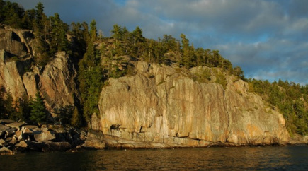
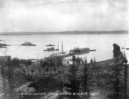
The Hudson’s Bay Company built a post at Michipicoten in 1797.  The first factor (boss) for the Michipicoten Post was Henry John Moze who arrived at Michipicoten on June 8, 1797 after paddling from Moose Factory and waiting 11 days at Missinabi for the lake ice to thaw.  Moze was accompanied by his “Indian Guide” and three company men to assist in carrying goods and help in building the new post.  The choicest location for a post at Michipicoten however was already taken by the HBCo’s main rival, the North West Company.  It’s a long story, but suffice it to say, both companies could not compete and in 1821 the two amalgamated as one under the banner of the HBCo.  Due to Michipicoten’s strategic location on the East/West trade route through Lake Superior-Georgian Bay-French River to Montreal, AND the North/South route from Lake Superior to James Bay, the HBCo established their Lake Superior District Headquarters at Michipicoten from 1821 to 1887.

As a result of the location of the HBCo. Post,  Michipicoten was the centre of activity.  Local Indigenous residents who at one time roamed the land with the seasons and food sources, began to set up permanent residence near the Post complex on the banks of the Michipicoten River where it meets the Magpie.  Michipicoten River Village can trace its perpetual roots well back into the 18th century.  Indigenous seasonal occupation in the vicinity has been scientifically dated 2000 years before present.

Interactions between Michipicoten’s earliest residents and the HBCo. did not always benefit both parties.  Common ailments and viruses easily fended off by the employees of European descent had devastating impacts on the North American’s physiology.  William Teddy and Louis Towab’s family lost 7 children in an epidemic in 1895-96.   

Much of the focus and objective of the trading empire was to ensure the local trappers became dependent on the goods and items traded.  These not only included items to ease daily existence, but also items which would have devastating effects on the social and economic character of North American cultures.  Guns changed the political boundaries, power centres and strategic rivalries.  Alcohol and its chronic ailments had devastating effects on individuals, families and entire communities dependent on each other to survive in a harsh and fragile landscape where starvation was not uncommon.

Over harvesting of local beaver and other fur-bearing mammals in the mid-1800’s meant Michipicoten needed to diversify to ensure the post could cover expenses.  Post employees became proficient fishermen, netting seasonal stocks of sturgeon, trout, herring, whitefish and pike.  Fish would be salted, packed in barrels and shipped to southern markets.  Michipicoten had a productive tinsmith and blacksmith shop.  Post employees also built wooden York boats to replace the more fragile birch bark canoe.  The post was utilized by travelling missionaries for sermons, baptisms, and marriages.  Indian agents also made annual visits to provide the annuities to Michipicoten First Nation members after the signing of the Robinson-Superior Treaty of 1850.  Michipicoten also operated as a post office and the first Mining Divisional Office of Ontario in 1898 after the discovery of gold on Wawa Lake in 1897 by William Teddy and Louise Towab.

Amenities at the Michipicoten HBCo post provided travelers not only supplies and a warm meal, but also a respite from sleeping in tents and out in the elements during long stretches of paddling on Superior and the Michipicoten River.  These guests and travelers included a long list of characters we learned about in that same grade school history class:  Sir Sanford Fleming, Alexander Mackenzie, Frances Ann Hopkins, David Thompson, Louis Agassiz, Governor George Simpson, to name just a few.

Although the post was instrumental in providing supplies, provisions and prospecting licenses to the rush of miners seeking their fortune in gold in 1898-99, Michipicoten was unable to compete with trading posts in the Chapleau area next to the Canadian Pacific Railway.  In 1904 the HBCo eventually closed the Michipicoten Post.

The HBCo. renewed its presence in Wawa when The Bay Department store opened its doors on Broadway Avenue in the early 1960’s.  The Bay was an integral part of the downtown business sector even when it was rebranded as the Northern Store and later sold to the Northwest Company.  Almost like the story came full circle.

The Bay is no longer a fixture in Wawa, and the HBCo. is no longer a Canadian company.  Even with American proprietors, the HBCo blankets, signature colours and cast of characters continue to represent a truly Canadian story that reflects our adventurous spirit and links with the incredible landscape we call home.  Wawa should be proud of the ties and strong connections it has to the people, communities and cultures which are woven into 350 years of the unique Hudson’s Bay Company story.

To discover more information about Michipicoten’s rich history, you can explore the Canadian Museum of History website for the "Michipicoten Pot"  or go to the Royal Ontario Museum website and search the online collection for a painting of the Michipicoten Post completed in 1897 by William Armstrong.
https://www.historymuseum.ca/cmc/exhibitions/archeo/ceramiq/pot12e.html
https://collections.rom.on.ca/objects/155729/michipicoten-headquarters-hudsons-bay-company?ctx=d662e4a4-cc00-43d7-b4e6-b00fb05a33d2&idx=0
2 Comments

Sault Star - February 4, 2012- There's gold in them hills: eastern shoreline of Lake Superior has brilliant past

5/22/2012

5 Comments

 
Picture
Grace Gold Miners and cook staff, 1908
If you enjoy watching shows like Gold Rush Alaska  and  reading about the famous Klondike Gold Rush, you might be surprised to know that  the rugged eastern shoreline of Lake Superior is also home to a dynamic gold  rush history which continues to this day.
 
A picnic in 1897 on Mackey Point on scenic Wawa Lake was the staging area for  Algoma’s first gold rush when Louise Towab and William Teddy uncovered a gold  laced quartz vein.  While the  Klondike gold fever was still fresh in everyone’s blood, one thousand hopeful souls flocked to the tiny Michipicoten River Village and Hudsons’ Bay Company post.  Visions of rich placer gold  fired their imaginations. Every creek bed, river and stream were staked and panned.  
 
By September 1897, some 1,700 claims were staked. The area was proclaimed a mining division and the first Ontario Mining Recorder’s Office was set up at the  abandoned Michipicoten HBCo. Post.  WaWa City was surveyed and registered in 1899.   The gold seekers soon discovered that there were no nuggets to be  had.  The most productive “gold  mine” in the area was the local hotel and tavern known as the Balmoral Hotel,  which sat where the Lakeview Hotel presides  today.
 
The rugged Michipicoten mountains did reveal their worth to  those more patient and practical prospectors who secured finances and resources  to drill, explore and develop some of the more profitable veins hidden beneath  the forest floor.   Dozens of  mining camps began to dot the landscape.  Of note during this first gold boom were the Grace, Norwalk, Jubilee,  Sunrise and Kitchie Gami.  In March  1903 newspapers reported “8 gold bricks  valued at $8,630 were received at the Imperial Bank from the Grace Mine, result  of 4 weeks’run.”  At the  current price of gold these bricks would have been worth over  $700,000.

The stock market crash of 1929 threw many in despair.  But in Wawa the gold rich quartz veins  called out to many who were driven by sheer determination to make a profit.  The high unemployment rate in Sault  Ste. Marie at the time led to an influx of grubstaking.   Merchants would fund grubstakers to travel up the coast to  Michipicoten and WaWa City to look for gold with the understanding that if gold  was found, the merchants would get their share. New gold veins were uncovered,  many new mines were opened and some of the original abandoned mines were dusted
off and reactivated.
          
Many of these grubstakers added their muscle and long hours to  the hard-working crew at places like the Minto, Darwin and Parkhill mines.  Labourers were told they would not be  paid until the mine actually poured its first gold brick.   Even though it was the “Dirty Thirties”, a headline in the Sault  Daily Star on January 6, 1932 read “Michipicoten Snaps Fingers at Depression,  Advances More in 1931 Than in All History.”  The Parkhill was mining veins that were  producing 1.9 oz/tonne at 50 to 100 tonnes per day.   The price of gold per ounce in 1932 was $20.67.    The price of gold today is $1685.00/oz.  Local gold mines today on average  produce 850 tonnes of ore per day which assay at approximately .3  oz/tonne.
 
During this second Wawa Gold Rush, immigrants flocked to the  many mine sites which came to be known as Gold Park.   Many could not speak English and were unable to find jobs anywhere else  especially for the relatively higher mining wage of $.50/hour.   Life in Gold Park was good.   The area boasted 300 souls while the Wawa town site was little more than  a supply depot. With the onslaught  of World War II, iron ore became the new resource on demand and gold mines were  quickly phased out. Workers and  families at the Gold Park communities moved themselves, their furniture and  sometimes their homes to the booming communities of Wawa and Sault Ste  Marie.

Gold mining activity in Wawa was reignited in the late 1960’s,  when the original Cora shaft of the Jubilee gold deposit was reopened.  In the late 1980’s old mine shafts from  the past 80 years were pumped out at sites like the Sunrise, Kozak, Canamax,  Kremzar and Citadel.  Today the  high price of gold and advanced mining technology continues to encourage  exploration of the original gold veins of the 1897 Wawa gold rush.    Gold mining is still an important part of the unique resource based economy of Northern Algoma at Wesdome, Richmont and Edward Mines.

5 Comments

Sault Star - October 29, 2011 - Lake Superior shipwreck stories enough to blow you away

4/11/2012

0 Comments

 
Picture
Golspie after it was first launched as the Osceola in June 1882
Superior’s Gales are once again upon us.  While we huddle in our 21st century homes
listening to the shuddering soffit, the wind whistle down the chimney, hoping the neighbors tree doesn’t decide to drop itself on our garage, it is hard to imagine the plight of shipwrecked souls caught out on Superior in days past. The violence, bone-chilling temperatures and the unforgiving topography of the east shore of the largest Great Lake is legendary.

The earliest known shipwreck north of Montreal River Harbour was a passenger-freight steamer called the ACADIA.  During heavy seas, the boat ran aground near Grindstone Point south of  Old Woman Bay on November 6, 1896.  Built in Hamilton in 1867, the ACADIA was the first vessel built in North America to have a composite hull (oak planking over iron frames).  Loaded with 21,000 bushels of wheat, a hole in the hull sank the ship in 20 minutes in 12 feet of water.  Before it could be salvaged, the ACADIA was pummelled to pieces by the constant wave action on this exposed rocky point.  The crew survived but had to make the long and arduous trek to Gargantua Harbour more than 15 kilometres away. On a calm day kayakers and canoeists alike can still catch glimpses of twisted pieces of the ACADIA’s steel hull trapped  among the giant boulders at Grindstone Point.  The ships bell is now on display at the Agawa Bay Visitor Centre.

The imposing cliffs and impenetrable shoreline of Old Woman Bay claimed the wreck of the GOSPIE on December 4, 1906.  This 200 foot wooden steamer belonging to the MacKay Company of Sault Ste. Marie was downbound from Fort William with a load of supplies for the CPR when it became unresponsive during a fierce snow storm. The ship and its crew of 18 drifted approximately 60 miles/100 kms north from 25 miles off Whitefish Point to where it beached itself near the south of the Old Woman River.  Captain Boult managed to get everyone safely to shore only to find that they had very  few provisions.  He sent 12 of the  crew in a yawl boat to Michipicoten River where they could get supplies and send word to the ship’s owners.  Ill prepared for the fierce head wind and bone-chilling temperatures, the wet and weary crew abandoned the small boat and decided to walk along the coast to
Michipicoten instead.  Needless to say the journey was no easy task.  The Canadians in the crew fared better than the newly landed immigrants  who were quickly overcome with the cold and suffered from their lack of experience in the bush.

Imagine the surprise of Joe Legarde and his guests when 3 of the crew stumbled through the doors of the North Star Boarding House in Michipicoten River Village in the middle of the night.  The next morning, William Kimball, John Andre, Alex and Joseph Michaud manoeuvred a rescue boat out through the treacherous Michipicoten River mouth and scoured the shoreline for the remainder of the crew.  Four miles from the village the rescuers came across the half frozen men, one walking in his stocking feet.  The villagers spent the next day trying to warm the frozen hands and feet of the motley group.  Joe Legarde’s dog team took the worst of the crew to the Algoma Central Railway in Michipicoten Harbour where they were transported to the care of Dr. Grimshaw at  the Helen Mine.

On December 20, 1906, five of the GOLSPIE sailors arrived by tug in Sault Ste. Marie and underwent amputations for severely frost-bitten limbs.  One of the men
lost both his hands and his feet.  One poor soul succumbed to the ordeal after he contracted pneumonia.   A letter to the Editor of  the Sault Star on December 11, 1906 reported that an investigation by Magistrate George Reid found that the crew members were to blame for their own fate.   The plight of the GOLSPIE was the
subject of much parliamentary debate.   The parliament of the day used this tragedy as an argument for developing  workmen’s compensation which was gaining greater support during the  administration of Prime Minister Wilfred  Laurier.

Little remains of the GOLSPIE.  Some remember a ship’s boiler near the mouth of the Old Woman River. Early scuba divers remember a sunken  wooden deck in the southwest corner of the picturesque cove.   Rainbow fishermen sometimes snag wooden ribs reaching out of the sandy  bottom of the bay while trying to catch the big one.  Although little can be found of Superior’s sunken vessels, the stories and tales will continue to instil a sense of wonder and awe about the Lake, especially when the gales of November are upon  us.

0 Comments

September 24, 2011 - Sault Star - Power to the people - Plugging into Algoma's rich hydro history

2/7/2012

1 Comment

 
Picture
Michipicoten High Falls, 1908
Where would we be today without our electricity?  As Algoma’s  industrial  activities began to thrive and evolve at the turn of the 20th century, the abundant rivers and  plentiful waterfalls of the ancient Ojibway and fur trade river routes became the focus of hydro power developers. While Sault Ste. Marie becomes a centre for alternate forms of renewable energy sources, it is worth noting Northern Algoma’s long history of hydro-electric generation for over 125 years.

Attempts to harness the power of the rushing rapids on the St. Mary’s River began in 1875.  It was not until 1894 when Francis Hector Clergue arrived on the scene with his background in hydro development in the U.S. that Sault Ste. Marie had a reliable
source of power for the newly incorporated city.  Always one to want to maximize profit, Clergue knew that lucrative industrial development needed to go hand in hand
with an efficient and cost-effective power generation venture.

The formation of Algoma Steel in 1901 included ownership of water power rights on the St. Mary’s River and the current power canal was constructed.  In 1916, organization at Algoma Steel led to the emergence of Great  Lakes Power Company which took over the rights to water power development on the St. Mary’s. Twenty-four power generation units were installed at the station, many of which were still being utilized prior to the plants replacement by the F.H.Clergue Generating Station
in 1981.  
 
The dramatic succession of cascades over the 90 foot Michipicoten High Falls on the Michipicoten River was once the home of the infamous  Long Portage (2.8 kms) for centuries.  It also became the site of the first hydro operation in Northern Algoma. 
D. B. Deitweiler of Berlin (Kitchener), Ontario completed the “run of the river dam” in 1907 to provide power to the Helen Iron Mine and gold mines in the area. In 1906, the birth the Magpie Mine north of Wawa led to the construction of a hydro dam at Steephill Falls on the Magpie River.  Steephill produced electricity for the 100’s of miners and their families at both the  Magpie and the Helen Mine until 1924.  The dam was abandoned and can still be viewed today as one of the only remaining sites of a flat buttress style dam in Canada.

In 1927 the Michipicoten High Falls hydro plant was purchased and upgraded by the
Algoma District Power Company Limited.  In 1929, a 112-mile transmission line was completed from High Falls to  Sault Ste. Marie so hydro could be purchased by Great Lakes Power to supply the growing needs of the Sault and area.  
 
The impressive scenery along the Montreal River depicted by the Group of Seven provided the backdrop for the construction MacKay and Andrews power generating stations in 1937 and 1938 respectively.  The MacKay station today has the largest generating capacity of all the Northern Algoma plants at  62 mega watts (mW) and has a reservoir upstream which extends approximately 40 kilometres.  
 
Below normal water levels and increased industrial growth and development throughout Algoma in the 1950’s heightened the need for expansion of  hydro generation abilities  throughout the district. The Scott Falls plant, located 1.5 miles downstream from High Falls on the Michipicoten was producing power by 1953. Two miles upstream from High Falls, the McPhail Falls hydro plant was completed in September of 1954.  Four years later, the last dam on the Michpicoten at Hollingsworth was constructed 9 miles upstream from the McPhail location. 
Downstream of the MacKay, the Gartshore (1958) and the Hogg (1965) completed the collection of hydro generating stations on the Montreal River.

Lucrative developments in the big business of power generation  led to the redevelopment of facilities at Steephill Falls as well as 2 brand new operations on the Magpie River at Scenic High Falls and the Mission Generating Station at Silver Falls.

In  2011 the flow of hydro power pulsing through our homes and communities seems to  have become as necessary to our everyday existence as the blood flowing through
our veins.  The history and health  of the water flowing through the St. Mary’s, Montreal, Michipcoten and Magpie Rivers is just as essential.
1 Comment

August 27, 2011 - Sault Star - Long abandoned industry often leaves something sweet in its wake

1/21/2012

2 Comments

 
Northern Ontario and  wild blueberries go hand in hand.   Wawa’s own “secret” blueberry patch is one of Northern Algoma’s most popular picking grounds.  Both high and low bush blueberry plants  thrive in this unusual environment amongst abandoned railway beds, hydro dams,  open pit mines, unique geological features and a Hollywood movie backdrop. 
 
Blueberries thrive in the rugged Canadian Shield landscape where for centuries, forest fires were nature’s way  of clearing the land and welcoming the emergence of the coveted blueberry  bush.  Journals and diaries of  Canada’s first explorer’s record the  practice of the local first nation’s people setting fire to sections of forest  in order to encourage berry growth.  In 1855, a fire started by native’s burning a blueberry patch near Lady  Evelyn Lake, west of Lake Timiskaming, ignited a massive fire which burned over  2000 squares miles of forest and reached as far west as the Michipicoten River  Village area on Lake Superior.
 
In 1921 a forest fire swept through the  Magpie River Valley, WaWa  City and destroyed all of  the buildings at the abandoned Helen Mine.   Another forest fire in 1946 was successfully rerouted past the Wawa townsite but burned much of the same terrain along the MagpieRiver  north of Wawa  Lake.
  
While most northern forests thrive after a cleansing fire enriches the soil, the natural re-growth of plants was hindered in this region by the sulphur dioxide fumes that blew across the landscape from Algoma Ore Division in Wawa.  The sintering operations at Algoma Ore  began to process siderite ore in 1939.  During the early years high contents of sulphur fumes had a devastating effect on the vegetation growing downwind of the mill. As environmental concerns grew and government legislation became more stringent, sulphur fumes decreased and the boreal forest began to reclaim the  barren landscape.  Since the closure of operations at AOD in 1998, the re-vegetation process has been  noticeably dramatic.

Despite the blue fume clouds that once floated across the valley, avid blueberry pickers would hitch a ride on the ACR on Sunday’s when the plant was shut down, or when the wind was blowing in a more favourable direction.  The Algoma Central Railway line criss-crossed through the blueberry fields from 1912 until the early 2000’s when the rails and ties were removed.  The first section of track in this area was constructed from Michipicoten Harbourand the Wawa Station to Hawk  Junction.  This rail line was at  one time a vital link for Wawa residents to the outside world.  It carried everything from ore, pulpwood and fuel, to newborn babies, the
Eaton’s catalogue and the Christmas Turkey.  
 
Siderite Junction (or “Four Corners”) was the cross point of the main railway line to Hawk Junction with the sideline which ran into the Sir James Open Pit Mine. Constructed in 1958 this railway bed was  in operation until shortly after the mine shut down in 1967.  The abandoned railway beds now make for a reliable and scenic access road  for berry pickers, cyclists and snowmachines alike. 
  
Access to Wawa’s famous blueberry patch from the west carries berry pickers across the Steephill Falls Dam operated by Brookfield Renewable Power Inc.  For those who are observant, you can still see the remains of the first hydro-electric generating station built on the Magpie River in 1913 to supply power to the Magpie Mine 20 kms north.  This flat-slab  buttress dam was abandoned in 1927 but remains as one of the only examples  of early hydro dam construction of this design in Canada.  In 1978 it was used as a Hollywoodbackdrop for the movie Rituals starring Hal Holbrook.  
  
In 2002 the Magpie River Terraces Conservation  Reserve was created along the Magpie to recognize and protect a series of some  of the best preserved lake and river terraces found along the Lake Superiorshoreline.  These unique geological formations were created by the dropping lake levels in the Lake Superior Basinafter the recession of the Wisconsin Glacier 10,000 years ago. 
 
Whether you call it the blueberry patch, the fume kill, the treeless zone, or the Magpie River Terraces Conservation Reservation, everybody knows that Wawa’s “secret”blueberry picking grounds are a unique asset to the rich natural and cultural heritage of the Northern  Algoma region.

2 Comments

July 23, 2011 - Sault Star - Agawa Rock Pictographs

10/12/2011

2 Comments

 
Picture
Agawa Rock cliffs - photo provided by J. Cooper

Photo Caption:  Agawa Rock cliffs - photo provided by J. Cooper

Where can one stand on a 5 foot wide granite ledge with the vast expanse of Lake Superior at your back, unpredictable waves reaching for your feet, and a 70 foot cliff adorned with ancient rock art only inches from your face?  This question can be answered by the adventurous tourists who descend the rugged path down to the Agawa Rock Pictograph site today, just as it could have been answered by the Ojibway artists, paddlers and fishermen of the past 300 years.

Agawa Rock is located along some of the most dramatic Superior shoreline 150 kilometres north of Sault Ste. Marie.   A granite wall of quartz, the bedrock juts out of the deep, green depths of Superior near the traditional Ojibway summer settlement sites at Agawa Bay and Sinclair Cove.  The Rock, as it is affectionately called by the summer students who are stationed at the site to provide interpretive tidbits to tourists, was a natural billboard for Ojibway ancestors to leave messages for future visitors to the site. 

The pictographs consist of faded drawings depicting animals, canoes and mythical creatures believed to inhabit the Lake and the surrounding shoreline.  The red ochre symbols are scattered along the rock ledge mere feet from the waters edge.  They reflect the lives and epic tales of the Ojibway people who have inhabited this dynamic landscape for centuries.

The existence of the Agawa Pictograph site was first documentd by Henry Rowe Schoolcraft in the early 1800’s after he interviewed Chief Shingwaukonce.  Schoolcraft did not visit the site, but was given a detailed drawing by Shingwaukonce of the symbols and artwork as he remembered them.

Although Agawa Bay was a regular waypoint for the brigades of fur trade canoes and early European travellers, there are few if any references to the pictograph site included in any of the journals and diaries kept by those who recorded their journeys from Sault Ste. Marie to Michipicoten, Fort William and beyond.

As the Agawa Bay area became more populated by commercial fishermen, lighthouse keepers and tourist operators, the paintings became a backdrop for additional “artwork” added to the site.  In 1879, a popular sportsman’s magazine published in New York City made note of the Agawa paintings as part of their regular tour during their annual fishing trips.  However this particular year the author stated “Last year, when I passed there, I found the frost scaled great pieces off the rocks, and the best of the pictures are gone forever.”*

In 1944 Lake Superior Provincial Park was established as a response to public concern for the protection and preservation of public land from encroaching development north of Sault Ste. Marie.  In 1946 a survey of the park’s assets and resources was conducted yet cultural sites and locations were not included.  No mention was made of Agawa Rock or its significance to the character and diverse heritage values in the Park.

In 1958, while conducting a survey of rock art in the Canadian Shield, artist and author Selwyn Dewdney “rediscovered” the Agawa Rock Pictograph site.  His passion and knowledge of the traditions and stories behind native rock art highlighted the significance of the Agawa Rock location and brought it to the publics’ attention.  After his death in 1979, the Ministry of Natural resources planted two stands of white pine at Agawa Bay to honour his memory.  The family also erected a plaque in a shady section of the granite cliff face, only a few metres away from the faded red ochre symbols that fascinated him.

Today the Agawa Rock Pictograph site is one of the most famous pictograph sites in Canada.  A paved road and rugged trail lead thousands of travellers each year to its dramatic granite ledge.  The adventuresome paddler and fishermen are provided the most authentic view when they access the site from the water.  Whether you were once drawn to the site as an Ojibway artist given the honour to leave your mark, or you are a curious traveller exploring the site by foot or canoe, the Agawa Rock Pictograph site is a dramatic piece of our cultural heritage which visitors will continue to appreciate for years to come.

* Forest & Stream – Rod & Gun.  Volume 12, Number 10 edition of May 22, 1879, New York, New York.

2 Comments

June 18, 2011 - Sault Star - Algoma's Iconic Miners

10/12/2011

4 Comments

 
Picture
Unknown prospector on the Magpie River Silver Falls Bridge, c. 1925
Click ere to edit.


Thomas Surluga was born in Krizisce, Croatia in 1907.  As a teenager he found himself bound for Northern Ontario and quickly mastered English and the use of a pick and shovel.  Tom first came to the Wawa region to work on the completion of the new power plant at Michipicoten High Falls in 1930.  In 1931 Tom took up prospecting with Cliff Miller for $2.50/day along the Catfish Creek and Black Trout Lake north of Wawa.  Supplies were loaded in a canoe, poled up the currents of the Magpie River and portaged over a mile and a half.  Though nothing substantial developed in this area, Tom had caught the prospecting bug.

From 1950 to 1960 Tom was drawn to the abandoned Michipicoten gold mines south of Wawa Lake.  He staked and re-staked mining claims in the vicinity of the old Cora and Jubilee mine sites.  On a hunch Tom re-staked his abandoned claim in September 1960 and 3 days later was negotiating its sale to Pango Gold.  Surluga Gold Mine was formed in 1962.  In 1966 at the age of 73, Tom drilled the first hole and helped celebrate in the excitement of the development of one of many gold mine operations in Wawa’s long mining history.

Between 1968 and 1969, over thirty thousand tonnes of rock were removed from the mine workings producing 2,300 oz of silver and 9,000 ounces of gold. The original Surluga Gold Mine operated as the Pango Gold Mines and Pursides Gold Mines Ltd from 1973 to 1980.  It was last operated by Citadel Gold Mines Inc. from 1980 to 1999.  The towering head frame was a constant site for Wawa residents scanning the forest topography along the south shore of Wawa Lake. 

A gravel access road from Hwy 101 to the Surluga property was once a popular route called the Surluga Road.  For Wawa residents, the name Surluga instantly conjures images of a meandering gravel road, abandoned headframes, rusted mining equipment and forgotten ghost towns.  It was regularly travelled by local history buffs, grouse hunters, snowmobilers and those residents searching for any familiar sign of the numerous deserted mines and abandoned town sites that were once a part of the lucrative boom and bust mining economy of the 1900’s. 

Unlike Tom, Joseph Ernest Aime Breton was a local boy to the core. Born in Sault Ste. Marie, Ontario in August 1907, Aime was raised in a large family whose parents were involved in the hotel industry.  Aime loved the wilderness and people.  He could run a hotel just as easily as he could trap, prospect, and entertain with his boxing prowess and famous one-man wrestling match.

During the Depression years, Aime found work at the Grace Gold Mine and the Wawa Gold Fields on the south shore of Wawa Lake.  In 1935 he moved his wife Bea and family from Sault Ste. Marie to Wawa after purchasing the town’s only hotel, the Lakeview.  When the hotel burned on Easter Weekend in 1944, the Breton’s rebuilt the current Lakeview, sold it to the Perkovich family and returned to Sault Ste. Marie to run the Central Hotel on Queen Street East. 

Aime was always interested in mining and recognized the potential value of Northern Ontario’s vast undiscovered mineral resources.  He is celebrated as playing a significant role in the initial discovery of the substantial uranium deposits between Blind River and Sudbury.  The claims he staked in 1948 were later transformed into 12 uranium mines, 10,000 employees and the prosperous town of Elliot Lake in 1954.   Aime’s prospecting ventures also resulted in the 1959 discovery of copper in a creek bed along Hwy 17 north of Sault Ste. Marie near Batchawana Bay which later became a mine operated by Tribag Mining Company.

In the spring of 1973 Wawa residents mourned the passing of Aime who lost his life on Lake Superior after his small fishing boat drifted off shore.  As a result of this tragic incident, Ontario’s search and rescue protocol’s and policies were revamped and readjusted to provide local communities with stronger and more efficient channels of communication with various emergency response teams.

Aime Breton and Tom Surluga are just two of Algoma’s many colourful pioneers whose hard work, perseverance and dedication to family and community were the cornerstone of life in this unique corner of Northern Ontario.
4 Comments

April 23, 2011 - Sault Star - Superior Lightkeepers and the Lambton

10/12/2011

1 Comment

 
Picture
Michipicoten Island East End Light c. 2005
As the spring sun begins to shrink the layers of ice on our lakes and streams, mariners and Coast Guard personnel answer the call to return to navigate Superior’s clear blue waters.  Although the number of vessels and passengers along the rugged east Superior shoreline has dramatically decreased over the past century, the dramatic scenery, vast expanses of remote shoreline and hidden dangers remain unchanged.

The Government of Canada commissioned the construction of lighthouses to guide the growing number of Captain’s plying the unpredictable Superior coastline.  The first lighthouse on Lake Superior was built at Quebec Harbour on the south shore of Michipicoten Island in 1872.  In 1886, the most remote lighthouse on the entire Great Lakes was constructed on a tiny island next to Caribou Island, 48 kilometres south of Quebec Harbour and 104 kilometres southwest of the nearest shipping port at Michipicoten Harbour. In 1889 a small lighthouse was built to guide fishing vessels and vacationers to the sheltered docks of Gargantua Harbour.  The ore boats and passenger steamers welcomed the wooden lighthouse at Perkwakwia Point near Michipicoten Harbour in 1902. 

Navigation upgrades to the active shipping lanes along the eastern shoreline meant a new light station at Caribou in 1911, a similar lighthouse tower on the East End of Michipicoten Island in 1912 and a new light standard and lighthouse in Quebec Harbour and nearby Davieux Island in 1918.

The men and women who were given the responsibility of maintaining these beacons of light and safe haven were both resilient and resourceful.  Three generations of the Davieux family manned the Quebec Harbour and Davieux Island lights on Michipicoten Island.  For almost 6 decades, three generations of the Miron family were keepers of the tiny Gargantua light at the entrance to Gargantua Harbour.

William Sherlock was the first keeper at the Michipicoten Island East End light from 1912 to 1923.  He made headlines in 1913 when he decided that he and his family would not return to Sault Ste. Marie in December to wait out the winter season.  His frugal reasoning saved him the cost of city rent and was no doubt safer than taking passage on Superior during the most unpredictable time of the year.  William’s name made it to print again in December of 1916 when The Sault Star described the harrowing journey made by William and his son at the end of the shipping season.  Caught in a sub-zero northeasterly storm, the 45 km trip from Michipicoten Island to Gargantua Harbour took over a week, half of which was spent in their 18 foot boat in the open water, and the other half was spent walking in the snow from Sand River to Gargantua.

William Sherlock’s final headline took place in December of 1918 when George Johnston, the lightkeeper at the nearby Caribou Light telegraphed the Department of Marine in Ottawa that William had not showed up on the mainland at the end of the shipping season. Neither William nor his boat  were ever recovered.  William’s wife and two children assumed responsibility for maintaining the East End Light until 1923. 

In 1915, the Canadian government advised all lighthouse keepers that due to cost-cutting measures, employees and their families would no longer be transported to and from their points of charge at the beginning and ending of the shipping season.  Many felt that this bureaucratic decision sealed the fate of William Sherlock and feared that more Superior light keepers would meet the same end.  George Johnston and his assistant at the Caribou Island light waited 10 days after the end of the shipping season on December 15, 1919 before a break in the weather finally allowed them to set sail for Quebec Harbour.  Ice formations and a winter storm held them fast in the Harbour and then on Michipicoten Bay for 8 days until they finally reached the mainland on New Year’s Day.

In 1921, Ottawa finally relented and commissioned the Canadian Government Ship Lambton to transport all the lighthouse keepers and their supplies to and from their lights. In mid-April 1922 the Lambton set sail from Sault Ste. Marie during a late winter storm and delivered the Miron family and their supplies at Gargantua Harbour.  On April 19 the Lambton left the shelter of the small fishing station heading north and was never seen again.  As the shipping season commenced, vessels navigating the east shore reported that none of the lighthouses north of Gargantua were operating.  Somewhere between Gargantua and Caribou Island on April 19, 1922, the CGS Lambton sank with all 22 passengers on board including George Penefold who was George Johnston`s replacement keeper for the Caribou Island Light, and William Reid, keeper of the Michipicoten Harbour light since 1915.

Many of the lighthouses and the keeper`s dwellings have been torn down. The Gargantua lighthouse was washed away in November 1940.  The Michipicoten Harbour light house was the last to be automated on the Ontario shoreline in 1991.  The Davieaux Island light continues to shine.  The Caribou Island and Michipicoten East End Light are the only 3 active flying-buttress style lighthouses remaining out of 6 built across Canada in the early 1900`s.  In 2011 the remote Caribou Island lighthouse celebrates a century of safely guiding ship`s Captains through the unpredictable Superior waters.
1 Comment

March 26, 2011 - Sault Star - Francis Hector Clergue's rich legacy remains in bloom

7/6/2011

0 Comments

 
Picture
Michipicoten Harbour - circa 1920 with Clergue's Wigwam Island on the left with a suspension bridge to the shoreline.
How would you react if a lump of iron ore from the remote hills of Wawa Lake was placed in front of you?  If you were Francis Hector Clergue, your pulse would quicken, your imagination would go into over drive and visions of Algoma railways, steamships, smokestacks, hydro dams and blast furnaces would take possession of your soul.

Born in Brewer, Maine in 1856, Francis Hector Clergue was a dynamic man with boundless energy, imagination and vision.  Representing a group of Philadelphia financiers, Clergue was initially attracted to Sault Ste. Marie for its hydro-generating potential.  After obtaining power generation rights on both sides of the St. Mary’s River and constructing a 20,000 horsepower facility, Clergue set his sights on seeking out and creating his own industries to consume this electricity.

In 1898, prospectors Alois Goetz and Ben Boyer unearthed a rich iron vein on the mountain north of Wawa Lake.  A sample of ore from this vein was placed on Clergue’s desk.  He immediately purchased the claims and began developing the Helen Mine (named after one of his sisters).  Clergue recognized that Wawa’s resource rich wilderness was the fuel to feed his industrial empire in Sault Ste. Marie.

By 1901, trains on the Algoma Central and Hudson’s Bay Railway were carrying ore, freight and people on the 12 mile line from Wawa to Michipicoten Harbour.  That same year, the inaugural fleet of the Algoma Central Steamship Lines was carrying ore, pulpwood and supplies to Sault Ste. Marie and across the Great Lakes.  In 1903 the newly constructed Algoma Steel plant on the north bank of the St. Mary’s River was receiving haematite iron ore from the open pit operations at the Helen Mine.  With the assistance of his brothers Ernest Victor and Bertrand Joseph, F.H. Clergue opened the Josephine iron mine near Hawk Junction, and the Grace and Gertrude gold mines south of Wawa Lake (all named after the Clergue sisters). 
Clergue’s greatest desire was not so much to build a profitable empire, but more the satisfaction of taming a wilderness and hearing it hum with the sound of industry.  Within 5 years of the Wawa iron discovery, construction crews were busy laying tracks north of Sault Ste. Marie for a main line of the AC&HB Railway optimistically setting its sites on the shores of the Hudson’s Bay.  Bush workers combed the Algoma forests cutting railway ties, lumber, and pulpwood to fuel railroad construction and the St. Mary’s Pulp & Paper Mill.  The Algoma wilderness attracted waves of ambitious prospectors staking every rock outcrop and mountain that had potential for gold, iron, silver, copper and lead.

F.H. Clergue and his siblings frequently visited the Michipicoten area.  His brother Ernest Victor was a partner in the Lake Superior Power Corporation which was responsible for construction of the High Falls power generating station on the Michipicoten River in 1904.   Ernest was also one of the first managing supervisors at the Helen Mine until a heart attack on a particularly rugged Wawa portage sent him back to the U.S. for medical treatment and his untimely death.  While in Wawa, the Clergue family would stay in the Factor’s grand home at the Michipicoten Hudson’s Bay Co. Post or at Francis’ 2-storey home on a tiny island in Michipicoten Harbour named Wigwam Island.

F.H.Clergue’s visions were not always supported by sound financial principal.  Although history records his poor administrative skills, his unprecedented legacy to the growth and development of Algoma has never been denied.   Clergue died in 1939 in Montreal.  His summer home in Michipicoten Harbour was washed off the Island during a violent November gale the next year.  Remnants of the lilacs, rose bushes and hawthorns planted at the H.B.Co. post by the Clergue sisters can still be found at the abandoned post site and scattered throughout gardens in Wawa.  Much like Clergue’s industrial empire, these hardy stems continue to survive the test of time and have adapted themselves to thrive in our rugged northern Algoma landscape.

0 Comments

February 26, 2011 - Sault Star Wawa vs. Wolves - call it the nature of the beast

6/15/2011

0 Comments

 
Picture
Sled dog team and Michipicoten River Residents in front of St. Margaret Mary Church c. 1920

Those of us who enjoy our after dinner stroll with Fido in tow should be aware that we are not the first residents to anxiously glance toward the shadows near the edge of town and beyond the comforting glow of our flickering street lights.   

Like all citizens of Northern Algoma, Wawa residents live in a remote and scenic corner of Northern Ontario. We know that our dues for being lucky enough to call this our home, is to endure suffocating black flies, blinding lake effect snow squalls, hungry black bears and curious wolves. 

During the severely cold winter of 1910-11, residents of Wawa (both human and canine), were desperate for meat.  A load of frozen beef hauled by horse and sleigh on the Grasset Trail between Missinabi and Wawa was trailed by a hungry pack of wolves for several miles.  One by one, quarters of beef were shoved off the sleigh and sacrificed to the wild dogs in order for the driver and horse to gain a mile or two before the pack reappeared to resume their next course.  Every morsel of meat gone, the driver feared that his horse would be next on the menu before reaching the safety of the Helen Mine camp near Wawa.

The sacrificed meat was originally destined to feed the 200+ hungry iron miners and their families.  The only other available meat in the vicinity was a small heard of caribou that wintered between Wawa and Michipicoten Harbour.  With permission from the Dominion Government, desperate residents dispatched the entire herd.

Wolves were a concern again during the winter of 1924-25.  The Sault Star headline for November 22, 1924 read “Joe Ball, of Michipicoten, With Clothes Torn Off, Won Desperate Battle with Wolf Which Attacked Him – Hobbled by a snowshoe and unarmed he strangled the wolf with a piece of trappers’ cord.  Beat off three others with snowshoe he was able to remove from his right foot.” (The Sault Star, 22Nov1924)

During the lean years of World War I, many citizens began raising their own live stock for food.  Alex Ross, a long-time resident on Broadway Avenue had to dispatch the largest wolf he had ever encountered in order to save one of his prize pigs.  “Skinned, the pelt was over 7 feet long, the biggest wolf I ever seen and the only one I ever got during my long years up here and he had to come right into my back yard and ask to be shot.” (The Sault Star, 4Jul1935)  Mr. Ross’s sow had both ears chewed off and became a local curiosity for Wawa residents and visitors alike.

In 1935, a Sault Star correspondent postulated the theory that the rise in daring wolf attacks in the Wawa area was due to the cross-breeding of timber wolves and domesticated dogs.  At the turn of the 20th Century, hardy sled dogs were a valuable addition to the winter work force at the bustling Michipicoten Harbour and railway operations.  With the collapse of the Clergue empire in 1903, the 28 dogs were “turned loose, and soon became wilder than the worst wolves and hunting in a pack, old timers say, [giving] rise to the stories of parties being trailed by hungry wolves …These dogs, in time, crossed with the wolves and gave rise to a large variety of timber wolf.”  (The Sault Star, 26Feb1934)

Advice for us from Joe Ball in 1924 after a pack of young wolves attacked him:  “A wolf is always hungry and is never hungry.  By which he means that he can defer eating till another day if he wishes to…Young wolves are notoriously venturesome like young dogs.  Anyone acquainted with young dogs knows how irresponsible they are…and it may be agreed that a young wolf has no more sense than a young dog…Mr. Ball has no fear of a wolf.  But he thinks no one should be foolhardy.” (The Sault Star, 22Nov1924)

Wawa vs. wolves will continue to be a story of respect for our nature and our heritage.

                                                                    --oOo--

To read the original 1924 Sault Star article on Joe Ball's harrowing fight with the wolves, go to my first blog "Wawa vs Wolves".
0 Comments
<<Previous

    Author

    Johanna Rowe

    Archives

    May 2020
    May 2012
    April 2012
    February 2012
    January 2012
    October 2011
    July 2011
    June 2011
    May 2011
    February 2011

    Categories

    All
    Acadia
    Agawa Bay Visitor Centre
    Agawa Rock
    Agawa Rock Pictographs
    Aime Breton
    Alex Michaud
    Alex Ross
    Algoma Central & Hudson
    Algoma Central Railway
    Algoma District Power Company
    Algoma Ore
    Algoma Steel
    Andrews Generating Station
    Balmoral Motel
    Ben Wyatt
    Bill Ennor
    Blueberry
    Brookfield Power
    Canamax Mine
    Captain Boult
    Caribou Island
    Caribou Island Lighthouse
    Cgs Lambton
    Chief Shingwaukonce
    Citadel Gold Mines
    Citadel Mine
    Clergue Generating Station
    Darwin Mine
    Davieaux Island
    Davieaux Island Light
    D.B. Deitweiler
    Dr. Grimshaw
    Edwards Mine
    Elliot Lake
    F.H. Clergue
    Fume Kill
    Gales Of November
    Gargantua Harbour
    Gartshore Generating Station
    George Johnston
    George Penefold
    George Reid
    Gold Park
    Golspie
    Grace Mine
    Grasset
    Grasset Trail
    Great Lakes Power
    Grindstone Point
    Hal Holbrook
    Hawk Junction
    Helen Mine
    Henry Rowe Schoolcraft
    Hogg Generating Station
    Hollingsworth Generating Station
    Hudson's Bay Co.Trail
    Indian Pictographs
    Jack Legarde
    Joe Ball
    Joe Legarde
    John Andre
    Joseph Michaud
    Jubilee Mine
    Kitchie Gami Mine
    Kozak Mine
    Kremzar Mine
    Lake Superior Provincial Park
    Lakeview Hotel
    Lambton
    Louise Towab
    Mackay Generating Station
    Magpie High Falls
    Magpie Mine
    Magpie River
    Magpie River Terraces
    Mail Carriers
    Mcphail Falls
    Michipicoten
    Michipicoten East End Light
    Michipicoten Harbour
    Michipicoten Harbour Light
    Michipicoten High Falls
    Michipicoten Hudson'S Bay Company Post
    Michipicoten Island
    Michipicoten River Village
    Mission Generating Station
    North Star Boarding House
    Norwalk Mine
    Old Woman Bay
    Pango Gold Mines
    Parkhill Mine
    Perkovich
    Perkwakwia Point Lighthouse
    Pursides Gold Mines
    Quebec Harbour
    Richmont Mine
    Rituals
    Scenic High Falls
    Scott Falls
    Selwyn Dewdney
    Shipwreck
    Siderite Junction
    Silver Falls
    Steamer Manitoba
    Steamer Rescue
    Steephill
    Steephill Falls
    St. Mary\\\\\\\\
    Sulphur Fumes
    Sunrise Mine
    Superior
    Surluga Mine
    Surluga Road
    The Sault Star
    Tom Surluga
    Tribag Mining Company
    Uranium
    Wawa
    Wawa Blueberries
    Wawa City
    Wawa Wolves
    Wesdome Mine
    William Kimball
    William Reid
    William Sherlock
    William Teddy
    Wolves

    RSS Feed

Powered by Create your own unique website with customizable templates.